Itinerary B


Day 1: San Cristobal Island: Lobos Islote & Interpretation Center

The first site will be Isla Lobos, a very small islet made of volcanic rocks that gets its name from the colony of Sea Lions (Lobo de Mar in Spanish) that live there. Here you can observe the behavior and interaction of Sea Lions living in a small community. Before taking the flight back to the mainland you will have some time to visit the town on your own for last minute shopping or people watching in the Galapagos. Transfer to airport.

For passengers that continue 15 days cruise, in the afternoon will be the visit to the Interpretation Center in Puerto Baquerizo, the local branch of the Galapagos National Park Service, where your guide will explain the formation of the islands, how the flora and fauna arrived and were established in Galapagos, as well as visit the corrals where there are several species of giant tortoises under the care of the National Park Service. For those of you arriving on that day, you will go from the airport straight back to the boat to show you to your accommodations. Then you will continue to the visit to Cerro Tijeretas located at 2 km from Puerto Ayora, is the only one site that you can see 2 different kind of Fragatas living on the same colony.

 
Day 2: Santa Fe Island & Plazas Island

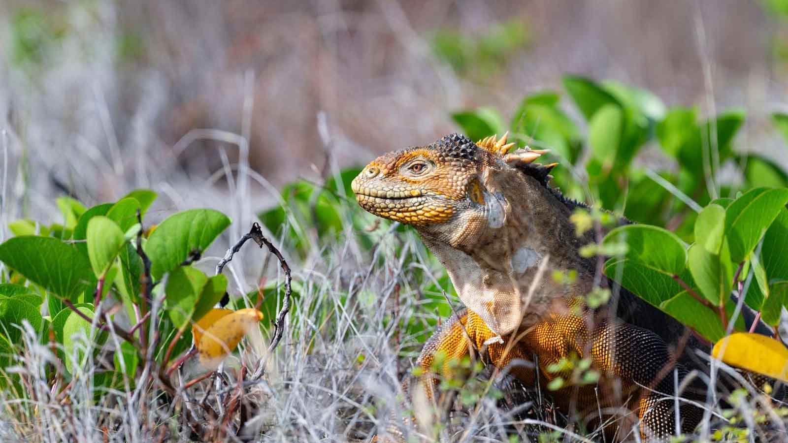
After breakfast on the yacht, you’ll continue to Santa Fe Island. Upon arrival to the island, you’ll be treated to a noisy  welcome from the local Sea Lion colony. Following your naturalist guide on the island paths you’ll reach Santa Fe’s main attraction, a towering forest of giant cacti. Scattered around the cacti trees you’ll see a number of the island’s indigenous sun-seekers: marine and land iguanas, the rainbow-streaked lava lizards and, if you’re lucky, land tortoises – the namesakes of the islands. After the walk you’ll dive into the salty sea and snorkel in the company of Sea Lions, Lion Fish and Sea Turtles. Finally, you’ll return to the yacht for lunch.

After lunch we’ll navigate to Plazas Island, where a large colony of Sea Lions lounge daily in the equatorial sun. Plaza also boasts excellent examples of typical Galapagos native flora such as the towering cacti “trees” that form the principal diet for both the Land Iguanas and the Cactus Finch. Other birds that may flutter by include Lava Gulls, Yellow Warblers and Red-Billed Tropicbirds.


Day 3: Santa Cruz Island: Charles Darwin Station & El Chato Reserve

You will visit  Tortuga Bay with a guide start the walk of one hour more or less , during this you will have opportunity to see lots of different plants, flowers, gecko lizards and birds. At your arrival you

It is a great location for swimming and even surfing. Located south-west of the touristic town of Puerto Ayora on the Galapagos Island of Santa Cruz.

It is considered by the majority of visitors as one of the most beautiful beaches in Galapagos. The sunsets here are just stunning.

There are two beaches at Tortuga Bay, the main beach is used for surfing due to its strong waves. If you want to swim and just relax you can head to the west side of the beach where the waters are calm.

The beaches are separated by Red Mangrove. Exotic and endemic plants of Galapagos Islands are also all around the beach.

In the afternoon, you are going to visit El Chato, a great place to see the gian tortoises.

Day 4: Isabela Island: Sierra Negra, Wetlands & Wall of tears

Your first visit in the morning will take place to Volcan Sierra Negra , will be a walk around 30 minutes to the lap of this famous volcano at Isabela Island.

Volcan Sierra Negra is a large shield volcano at the South eastern end of Isabela Island in the Galapagos that rises to an altitude of 1124m. Also is considered one of the oldest Volcano at the Islands.

In the afternoon after lunch, you will go to visit the humedales, which is a mangrove area with small brackish water lagoons that create the perfect environment for a small type of shrimp that serves as the food for the island’s flamingos.

Following this visit you will be transported to El Muro de las Lagrimas or “The Wall of Tears.” When the Ecuadorian government first took possession of the islands their main purpose was to harbor Ecuadorian prisoners; since there wasn’t much for them to do they were forced to carry rocks to a far location and build a wall. which nowadays is know as The Wall of Tears.

Day 5: Isabela Island: Punta Moreno & Elizabeth Bay

After night navigation you’ll arrive to Punta Moreno on the west coast of Isabela, a dry landing on a lava field. The vegetation found in this area is sparse and concentrated mainly in the mangrove area and around the lakes. It should be noted that the three kinds of cacti are found here.

The main attractions at Punta Moreno are the coastal lagoons amid black lava flows where there are several species of birds. Here you’ll have a panoramic view of three of the most active volcanoes in the Galapagos, which are Sierra Negra, Cerro Azul of Isabela Island and La Cumbre of Fernandina Island.

After lunch on board you’ll continue on your way to Elizabeth bay, located on Isabela Island`s west shore, which is an excellent spot for observing marine life. You’ll motor past a few islands where you can usually see Galapagos Penguins; this is one of the best areas to take their photos. A colony of these magnificent birds inhabit a rocky islet at the entrance to Elizabeth Bay.

We’ll let our boat drift through a small passage lined with mangroves and eventually emerge into an enclosed cove. We’ll turn the motor off and look in the sheltered waters for Marine Turtles, Rays, Flightless Cormorants, Sea Lions, and, circling overhead, Galapagos Hawks.

 
Day 6: Isabela Island: Caleta Tagus, Punta Vicente Roca & Fernandina Island: Punta Espinoza

The visitor’s site of Tagus Cove is located west of Darwin Volcano on Isabela Island. The entire distance of the trail is about 1800 meters. This was a favorite spot for pirates and whalers, and the tradition of inscribing the names of boats is a tradition still observed today. At the beginning of the walk, going up and passing the staircase, is a small cave where you’ll find inscriptions dating to the 1800s.

The trail, mostly gravel, leads into the interior, along Darwin Lake. During the walk, you can see various land birds and we’ll identify the characteristic vegetation of the arid zone. Finally, you’ll see the lava fields of Darwin Volcano.

Back on board for lunch and a short navigation to Elizabeth Bay on Fernandina Island

Punta Espinoza is a narrow ledge of lava and sand that extends from the base of the volcano to the sea. There is a vivid description from Captain Benjamin Morrell who witnessed and recorded and eruption of Fernandina in the 1820’s that probably gave rise to the Point. In 1975, there was an uprising, about 90 cm, which is why the pier built for landing can only be used during high tide.

Punta Espinoza is a place famous for its large colonies of Marine Iguanas as well as being the habitat of unique species like the Flightless Cormorant, the Galapagos Penguin, the Galapagos Hawk, and the Galapagos Snake, among others. It’s an ideal place to observe the lava cactus (Brachycerus Nesioticus), which grow on young lava and survive with little water.

After visiting Fernandina you will start the navigation to the central part of the Galapagos and on the way you’ll see Punta Vicente Roca, a mostly eroded volcano which now is a great site for seeing Blue Footed Boobies, Frigate Birds and other marine birds from the boat.

Day 7: Santiago Island: Puerto Egas & Rabida Island

James Bay is a black sand beach located on the west side of James Bay and northwest of Santiago Island. South of the beach is Sugarloaf Volcano, which has deposits of volcanic tuff, the same that helped the formation of the black sand beach. El Cráter is just north of this site, it has a saltwater lagoon, which during the summer dry season becomes a salt mine. Between 1928 and 1930 was the first exploitation of salt; but the efforts did not last long. Then again in 1964 a new attempt was made that lasted for some time.

After lunch on board we’ll navigate to our next destination, Rabida

Rábida Island consists of a red sand beach, a coastal lagoon behind the beach, and a loop trail. The approximate distance of the trail is 1.1 kilometers.

The color of the rocks and sand on the beach is due to the very porous volcanic material, which with the help of environmental factors (rain, salt water and sea breeze), has acted as an oxidizing agent.

The main attraction of this spot is the red sand beach and scenery, aside from the vegetation of the arid zone and the presence of native and endemic species.

 
Day 8: North Seymour Island & Baltra Airport

After an early breakfast you’ll disembark at North Seymour Island. Here you will see Frigate Birds, the clownish Blue-Footed Booby, and of course the ubiquitous Sea Lions. With luck you’ll witness the striking courtship display of the male Frigate Bird, in which he inflates a red balloon-like sac below his throat and struts his stuff for all of the young females. Seymour North, Plaza Sur, Plaza Norte, Baltra, northeastern Santa Cruz, Santa Fe and part of Española, were all formed by uprisings of underwater volcanic lavas. They were part of a volcanic lava table deposited in sheet form along cracks located on the ocean floor. The uprisings occurred sporadically and lasted more than a million years to reach its current level.

All marine fossils found in the archipelago are found in these islands and the best example is the North Channel side of Baltra. The fossils date from the Pleistocene, and specifically in the case of Baltra, one can say that these volcanic tables were close to the surface about a million years ago.

Return to the boat & sail to Baltra Island to catch your plane back to the mainland